Unmanned Vehicle Systems / DRONES

Using Small Unmanned Aerial Vehicle Systems FOR COUNTING SEABIRDS
Paul Pace
David Bird
INTRODUCTION
This study was a continuation of the previous year's work that investigated the use of a small unmanned aerial vehicle (UAV, drone) to census murres on Gull Island near the coast of Newfoundland. Typically, murres nest in dense colonies on rocky cliffs overlooking the sea. These areas are difficult to access by land and counting the birds from a small boat tends to frighten them and they fly from the colony. Following the previous year's work, camera resolution requirements and flight patterns were established. In this study we propose to use a small drone, “Sky Hero” to verify the predictions from the earlier work and to obtain high quality images to allow accurate counts. We also wanted to quantify the effects of the drone fly-by on the murre population.

IMAGING REQUIREMENTS
Following work done by John Johnson (Ref. 1) in the late 1950s and more recently the US Army's Targeting Task Performance (TTPs) criteria (Ref. 2), we determined the pixel resolution required to be able to detect, recognize (classify) and identify a murre. A common murre is about 38-46 cm tall which gives a width of about 15-20 cm. It has been determined from experience that it will require an image resolution equivalent to the TTP recognize(classify) criteria to be able to count the birds in dense colonies. This equates to about 15-20 resolvable pixels across the critical dimension of the bird, i.e. the width of the bird when it is standing on the rocks. This means the camera system must be able to generate about 1cm resolution on the targets. This was verified from the experiments carried out the previous year. We acquired a GoPro camera with a special 47 degree field of view lens and a 12 mega pixel imaging array. This allowed images to be taken with the required resolution from a slant range of about 30-40 metres.
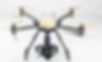
Figure 1: Sky Hero UAV
THE CAMERA
The camera was a special GoPro Hero 4 with a 12 mpixel imaging array and a 47 degree field of view (FOV) lens. The modulation transfer function (MTF) was measured to verify the resolution capability. The MTF results combined with the FOV were used to determine the slant range from the camera to the target that would ensure the above image resolutions were maintained. These distances could then be used to determine appropriate flight paths for the UAV.
THE UNMANNED AERIAL VEHICLE
The UAV selected for the experiments was the Sky Hero Spyder X8. It has eight rotors and it is equipped with a gimbal suitable for small cameras. It has a payload capacity of about 7 kg which includes the battery. It is controlled using a Pixhawk autopilot which allows for completely automated flight including take-off and landing. It is capable of following a pre-programmed way-point route controlled and monitored from a tablet computer ground station. The aircraft can also be flown in a semi-manual mode using a standard RC controller. Flight time is limited to about 17-20 minutes when flying the GoPro camera. Figure 1 shows the UAV.

EXPERIMENTAL RESULTS
To obtain the image resolution requirements it was determined that the special GoPro camera would have to be flown to within a slant range of about 30 metres from the colony. The critical question now becomes: What is the reaction of the birds?
To determine this, a flight trajectory was set up to fly parallel to the cliffs at a 30 metre slant range to the colony. A typical flight path is shown in Figure 2.
The reaction of the murres was monitored before the flight, during the flight and after the flight. A detailed summary will be provided in a second report; however, it was noticed that there was a significant response from the murre colony. Several birds flew of the cliffs, some abandoning their eggs
Figure 2: Typical Flight Path, 30m Slant Range
DISCUSSION
The results indicate that the performance of the system can be predicted using the TTP imaging requirements combined with the modulation transfer function analysis. This allows predictions for other camera and lens combinations .The special GoPro camera with the modified lens was able to produce the required resolution from a slant range of 30 metres.
A second issue to consider is the disturbance to the birds. This experiment indicated that there was a significant disturbance to the colony. It is suggested that in future work the drone should remain at a distance that does not disturb the murres. This could be accomplished by flying at longer slant ranges. Tests would have to be done to verify the acceptable range; however, flying at higher altitudes would require the use of high resolution digital cameras with longer focal length lenses.
Finally, the environmental issues and the ability to fly the drone from the island should be investigated further. The terrain on the island is very difficult for the operation of the drone as it is heavily wooded, rocky cliffs or extremely steep. It was difficult to find a level area large enough for automated take-off and landing. Future experiments should investigate flying a fixed-wing air vehicle from the mainland, a distance of about 2-3 km. Finally, wind and air turbulence have a significant effect on small UAVs. These tests were conducted at wind speeds only up to about 8 m/s. Further testing will have to be done in stronger winds to determine the feasibility of this concept.
Although the murres are not aggressive, it should be noted that other species on the island are very aggressive. It is noted that Herring Gulls defend their nests with vigor. In fact, a Herring Gull attacked the Sky Hero on its return flight to the landing area. The aircraft was lost into the ocean. This is another reason to fly at altitudes that do not pose a threat to the birds under study or the other bird species on the island.
FUTURE EXPERIMENTATION
-
Evaluation of a higher resolution camera with a longer focal length lens (narrow FOV). Stability and pointing accuracy will limit the narrow FOV. The added weight will also affect the flight time.
-
Flying a small fixed-wing aircraft from the mainland shore would also be worth investigating. A system with a range of about 5km and a flight duration approaching 1 hour might be required.
-
Evaluate the effects of the aircraft on the birds. Flying at higher altitudes would be an option.
-
Evaluate environmental effects, wind, turbulence, temperature etc.
REFERENCES
1. John Johnson, “Analysis of image forming systems,” in Image Intensifier Symposium, AD 220160 (Warfare Electrical Engineering Department, U.S. Army Research and Development Laboratories, Ft. Belvoir, Va., 1958).
2. Richard Vollmerhausen and Eddie Jacobs, “The Targeting Task Performance (TTP) Metric”, Modeling and Simulation Division, Night Vision and Electronic Sensors Directorate, U.S. Army CERDEC, Fort Belvoir, VA, 22060, Technical Report AMSEL-NV-TR-230.
Applications of Unmanned Vehicle Systems
TO WILDLIFE RESEARCH AND MANAGEMENT IN THE 21ST CENTURY
David M. Bird, Avian Science and Conservation Centre, McGill University
Small unmanned vehicle systems (UVS), formerly exclusive to militaries, are rapidly advancing in sophistication and availability to civilians. Ranging from hand-launched autonomous airplanes to terrestrial robots to underwater machines, they are increasingly being employed in such areas as agriculture, emergency services, meteorology, oceanography, geophysics and film-making. Another area that shows great potential for the applications of UVS and associated markets is wildlife research and management. Applications being carried out in various regions of the world today include monitoring breeding, wintering and migrating populations of colonially nesting birds, spawning salmon and orangutans, mapping breeding habitat of endangered species, tracking threatened caribou and polar bears in the far north, examining nest contents of raptorial birds breeding in inaccessible locations, and deterring poachers in Africa. As technology and industry continue to develop and the regulatory procedures begin to loosen, we anticipate an ever-widening range of applications to surface in this field. At McGill University and in partnership with many others, we have been conducting UAV research since 2007.
Below is a summary of those studies.


WATERBIRD STUDIES
Under the supervision of Dr. David Bird at McGill University, Dominique Chabot first completed his M.Sc. on the use of UAVs to monitor two species of geese. More recently in 2014, he acquired his Ph.D. degree with his thesis title being THE RISE OF UNMANNED AIRCRAFT IN WILDLIFE SCIENCE: A REVIEW OF POTENTIAL CONTRIBUTIONS AND THEIR APPLICATION TO WATERBIRD RESEARCH. The overall aim of this project was to help stimulate and guide the adoption of UAS in wildlife science by taking a distinctly rigorous, contextualized and integrated approach. This was accomplished by first presenting a detailed analysis of potential applications for UAS throughout the field of wildlife science based on the results of a systematic review of the current primary literature. Two case studies involving waterbirds were also presented, which served to evaluate, validate and demonstrate the use of a small UAS in genuine management-driven contexts. The first case study, involving the Least Bittern (Ixobrychus exilis), highlights the benefits of the UAS for collecting fine-scale habitat data in a wetland habitat that is challenging to navigate and assess at ground level. The second case study, involving the Common Tern (Sterna hirundo), demonstrates the advantages of using a UAS for studying and monitoring species that are highly sensitive to investigator disturbance. The examples provided by these case studies as well as the additional applications proposed in the review suggest far-reaching potential for UAS in wildlife science. Immediately following his graduation, Dominique took up a position with ING Robotic Aviation in Ottawa, serving as their environmental expert.
NEST CENSUSES OF RAPTORIAL BIRDS WITH ROTARY UAVs
AND BEHAVIORAL RESPONSES OF THE ADULT BIRDS
As part of his M.Sc. studies at McGill University under the supervision of Dr. David Bird, James Junda completed his data collection and is currently writing his thesis. We conducted a total of 113 UAV flight surveys of the nest contents of four raptor species: Osprey (Pandion haliaetus) in Montana, USA, 2013 as well as Bald Eagle Haliaeetus leucocephalus, Ferruginous Hawk (Buteo regalis) and Red-tailed Hawk (Buteo jamaicensis) in Saskatchewan, Canada, 2014. With a success rate of over 90%, this technique has been shown to be applicable and useful in a variety of nesting situations. Each survey was conducted using a small GoPro camera attached to a sub-3 kg rotary-winged Draganflyer X4 Drone. In the vast majority of trials, high-quality images of the nest contents were obtained, allowing for an accurate count of eggs or nestlings, as well as useful estimates of the nestling ages. Flight times were brief, lasting less than five minutes, with the majority lasting less than two minutes and the duration decreasing as pilot skill increased. We measured the parental response at each nest, recording key behaviors such as initial flush distances, call rates, flight behavior and dives. A large variation in parental nest defense response between species was observed. In general, we found Osprey to be the most aggressive, the two buteos to be the least aggressive, and Bald Eagles somewhere in the middle. We also measured variation within the nesting cycle, conducting 86 UAV nest surveys of Osprey and comparing parental nest defense response between egg stage and nestling stage. Finally, we approached active nests on foot without flying the aircraft, but still recording parental behavior. This allowed us to sort out the amount of disturbance caused specifically by the drone versus only human presence at the nest site. We demonstrated that drone aircraft can be a valuable tool for monitoring raptor nests, allowing for a flexible schedule of quick checks and less disturbance than current survey methods, while proving safer and more accurate checking of the nests from light manned aircraft. We plan to continue flying various models of quadrotor UAVs over the nests of a wide number of raptorial bird species to determine which machines and which species best lend themselves to this type of censusing technology, as well as developing ways to ensure the safety of both the UAV and the nesting birds.
WOODLAND CARIBOU STUDIES USING A FIXED-WING UAV IN GOOSE BAY, LABRADOR
This study is being conducted by Charla Patterson for her M.Sc. thesis research under the supervision of Dr. David Bird at McGill University and with the collaboration of Dr. Bill Koski, Dr. Paul Pace, and Brian McLuckie of Brican AeroSpace Systems. One of the major accomplishments of our experiments to date was the successful completion of a wildlife study with a UAV involving Beyond Line of Sight (BLOS) flights in September 2013. To our knowledge, this is the first official operation of a commercial small UAV under this flight regime in Canada, and it can be considered as one of the main accomplishments of this study. The quality of the imagery obtained was sufficient to find caribou, identify them as caribou, and identify some caribou-sized animal as adults or calves. The survey swath was also wide enough to provide suitable survey coverage to allow estimates of densities of animals in survey plots to be calculated. Future analyses will allow estimation of correction factors that can be applied to sightings in different habitats to account for missed animals because the animals are obscured by habitat features in the photographs. We conclude that surveys like the ones that were conducted during this study can likely be used to estimate densities and population sizes of caribou stocks. We also conducted some detectability studies using plywood sheets as surrogate caribou targets in four different habitats in the Goose Bay area. A major drawback of the 2013 tests is that they were conducted with a battery powered version of the TD100, which greatly limited the flight duration. Tests were highly successful for the distances travelled, but flight distance and time were limited to an hour and 20 min and tests of various systems for longer distances and for longer flight durations must be proven for many commercial operations to be viable. A fuel-powered version of the TD100 is currently undergoing testing that would allow the TD100 to fly for 30+ hours before landing to refuel. To be able to successfully repeat the surveys conducted here throughout the entire Goose Bay Practice Target Area from a single location, flight durations of ~4–8 hr are required, depending on where the operations base is located. Ms Patterson’s M.Sc. thesis has been accepted at McGill University.
THE USE OF UAVS TO DISPERSE NUISANCE BIRDS
This study, jointly conducted by Dr. David Bird of McGill University and Dr. Paul Pace at Carleton University, has been hampered by the difficulty in acquiring an Animal Use Protocol (AUP) from McGill University, mainly due to the concerns about the welfare of the targeted nuisance bird species. We are happy to report that we have recently acquired our AUP. Meanwhile, we have begun gathering background information on the types of aircraft available for the project. We have also acquired information on how nuisance birds have been dealt with by other researchers, including several recent articles concerning various dispersal methods. We have also purchased some bear bangers (AKA loud noise-makers) and we have designed a mount to hold 4 bangers to a small copter. We have conducted some banger firing tests to confirm the operation of the launch mechanism and verify the safety system. Dr. Pace has also set up a simulator and has conducted a few mission simulations to get an understanding of fixed wing vs rotary wing system performance. A fixed wing aircraft has been assembled and flight tests have been conducted. Flights with the payloads will take place in the fall of 2015. Our intentions are to test our system on European Starlings (Sturnus vulgaris) in several vineyards in the Okanagan Valley in British Columbia.


TRACKING WILDLIFE WITH UAVs
Also in partnership with Paul Pace, as well as Drs. Liana Zanette and Michael Clinchy of the University of Western Ontario, we are investigating the application of UAVs to track wildlife species bearing radio transmitters. The objective is to mount an antenna/receiver that will not only pick up signals from the transmitters on the animals so as to identify individuals but also relay the information to a ground station. As a test case, we are attempting to develop a receiver small and light enough to be affixed to a rotary UAV so that we can pick up signals from song sparrows (Melodia spiza) nesting on the Gulf Islands to know that the birds have returned from their wintering grounds. Thus far, we have been able to mount a receiver on a rotary machine and beginning field tests in September 2015.
ACKNOWLDEGEMENTS
We are very grateful to the Kenneth Molson Foundation, Brican Flight Systems, the Institute for Environmental Monitoring, the Animal Welfare Institute, and the International Osprey Foundation for their support over the years.
Peer-Reviewed Publications to Date
Chabot, D. and D.M. Bird. 2013. Small unmanned aircraft: precise and convenient new tools for surveying wetlands. J. Unmanned Vehicle Systems 1: 1--10
Chabot, D. and D.M. Bird. 2012. Evaluation of an off-the-shelf Unmanned Aircraft System for surveying flocks of geese. Waterbirds 35(1): 170-174.
Chabot, D., V. Carignan and D.M. Bird. 2014. Measuring habitat quality for Least Bitterns in a created wetland with use of a small unmanned aircraft. Wetlands. DOI: 10.1007/s13157-014-0518-1
Dominique Chabot
David M. Bird
Can Drones HELP OUR WILDLIFE?
Wildlife science generally refers to the study, monitoring and management of wild mammals, birds, reptiles, and amphibians (and occasionally fish), as well as their habitats. The monitoring and management components render it a distinctly practical and applied field of science, in particular because they routinely involve urgent objectives (e.g. saving threatened species before they go extinct, controlling nuisance species before they cause significant damage), with limited resources to tackle them. Moreover, wildlife is inherently challenging to study and manage --- wild animals tend to be elusive, wide-ranging, sensitive to human disturbance and/or dangerous to approach. In addition, the habitats they occupy tend to be remote, expansive, and/or otherwise challenging to impossible to access or navigate at ground level.
Wildlife science generally refers to the study, monitoring and management of wild mammals, birds, reptiles, and amphibians (and occasionally fish), as well as their habitats. The monitoring and management components render it a distinctly practical and applied field of science, in particular because they routinely involve urgent objectives (e.g. saving threatened species before they go extinct, controlling nuisance species before they cause significant damage), with limited resources to tackle them. Moreover, wildlife is inherently challenging to study and manage --- wild animals tend to be elusive, wide-ranging, sensitive to human disturbance and/or dangerous to approach. In addition, the habitats they occupy tend to be remote, expansive, and/or otherwise challenging to impossible to access or navigate at ground level.
Consequently, the science of wildlife biology has historically derived great benefits from various technologies that help to overcome these challenges. Notable examples include aircraft, remote sensing satellites, radar, thermal cameras, motion-triggered camera traps, projectile-based animal capturing devices and chemical immobilization agents, and a wide array of animal-borne electronic tracking and logging devices.
The twenty-first century has ushered in a steady rise in the development and application of a new technology that promises to offer further support to wildlife science: unmanned aircraft systems (UAS), also known as unmanned aerial vehicles (UAV), remotely piloted aircraft systems (RPAS) or, popularly, drones. Following decades of exclusive use by militaries, drones now continue to find new usages in an ever-growing variety of fields in the civil sector—including wildlife science—thanks to their ability to collect very high-resolution aerial data in a distinctly timely, repeatable and unobtrusive manner, notably over areas that are difficult to access or navigate at ground level.
DRONES FOR OPTICAL SURVEYING AND OBSERVATION OF ANIMALS
Much work to date has focused on surveying and observing wildlife species with various cameras, as drones are seen to offer a safe, convenient and low-disturbance means of acquiring high-resolution imagery of animals, particularly in locations that are difficult to access or survey from the ground.
MAMMALS
Drone surveying and observation of aquatic mammals has overall received the most focus out of any category of wildlife, owing to their inherently hard-to-access aquatic habitats, which in many cases are so remote as to be hazardous to survey by manned aircraft. Indeed, lives have been lost in the process of carrying out long-range aerial surveys of marine mammals in remote regions. The earliest accounts of aquatic mammal observation using drones involved tethered airship systems. A system equipped with a video camera was used to measure the length of manatees congregating in Homosassa River, Florida, while other have employed a similar system to monitor the responses of bottlenose dolphins to boat traffic in Sarasota Bay, Florida.
With the rise of more sophisticated autonomous drones, attention turned to larger-scale detection and monitoring of cetaceans, e.g. whales, dolphins, etc. However, to this day these endeavours have yet to move past the trial phase, mainly impeded by airspace regulations which tend to restrict drone flights to within visual line of sight of ground-level operators. There has been interest in proposed design considerations for a drone-based monitoring system intended to alert ships of risks of collisions with large cetaceans. Several studies have focused on a lightweight multispectral imaging system intended to be carried by small UAS, designed to detect cetaceans at or near the water surface. Others have studied using drones as a safer alternative to manned aircraft for large-scale monitoring of ocean-dwelling cetaceans, including trials with both decoy and live whales, an assessment of the potential suitability of various available drone models for performing such monitoring, and a comparison of marine mammal detections by live surveyors versus analysts of digital imagery. Proof-of-concept experiments definitely demonstrate that a drone can be capable of autonomously detecting and tracking moving whales at the water surface.
Hand-launched fixed-wing drones have also been used in Florida to monitor manatees, which are relatively more amenable than cetaceans to drone surveys due to their tendency to congregate in warm, shallow waters that can be overflown within visual line of sight of operators on the shore.) A larger catapult-launched system has been to survey dugongs in Shark Bay, Australia, followed by the development of an algorithm for automatic detection of the animals in the digital imagery. Finally, pinnipeds, e.g. seals, walruses, etc., are similarly amenable to relatively small-scale drone surveys due to their tendency to congregate at rookeries and haul-out sites, though reports of such surveys have been somewhat limited. One study in 2009 deployed a high-endurance drone from a ship to survey for Alaskan ice seals, and most recently a small vertical-takeoff-and-landing (VTOL) multi-rotor drone was used to census Antarctic fur seal rookeries and obtain morphometric data on leopard seals.
Large terrestrial herbivores have also been the subjects of drone-based surveying, though as with ocean-dwelling cetaceans it has been noted that airspace regulations as well as the limited endurance of small consumer-grade drones tend to preclude effective monitoring of these animals throughout their expansive ranges. Drones have been used to perform a head count at a bison range, while a small low-flying multirotor system equipped with a thermal camera has been designed to detect concealed meadow-dwelling roe deer fawns which are susceptible to being killed by pasture mowing machines. Other efforts have focused on African and Southeast Asian megafauna, namely elephants, rhinoceros and giraffes, including in the context of anti-poaching efforts. Image analysis techniques aimed at automatically detecting and counting these animals in drone imagery have also been recently developed.
Finally, drones have detected orangutan nests in as well as northern pocket gopher mounds in grasslands. One study demonstrated the automatic detection of rabbits in thermal imagery captured from a lift, intended to simulate a low-flying drone scanning for small concealed animals in the path of agricultural machinery.
BIRDS
For similar reasons to aquatic mammals, waterbirds have received the most focus to date when it comes to surveying birds with drones. Waterbirds tend to occur in hard-to-access habitats (e.g. wetlands, islands, offshore waters) that drones may conveniently overfly, as well as conspicuously aggregate in relatively small, open areas for various activities including breeding, foraging, roosting, moulting, and staging during migration. Moreover, waterbird aggregations tend to be sensitive to overt disturbance and even aggressive towards investigators (e.g. mobbing).
Although accounts of detection of various wading bird species in drone imagery were reported as far back as 2005, we evaluated a basic fixed-wing drone for surveying staging flocks of Canada and snow geese. There has been particular interest in using small, unobtrusive drones to survey dense and sensitive breeding colonies as an alternative to ground surveys or conventional aerial surveys, for example gulls, terns, and penguins. Reactions of non-breeding mallards, greater flamingos, and common greenshanks to small multirotor drones of varying colour, speed and approach angle have also been systematically assessed.
Another emerging application involves the use of small multirotor systems to perform nest checks, which is seen as a safer and more convenient alternative to either physical climbing or using conventional helicopters or light airplanes to survey hard-to-reach nests on trees, cliffs or artificial structures, and/or for highly defensive birds that attack intruders. Examples include surveying the nests of hawks, eagles and crows. Some researchers have also succeeded in capturing close-up imagery of white stork nests atop transmission towers by flying a fixed-wing drone overhead.
REPTILES AND AMPHIBIANS
Drones have not yet become popular for use in studying reptiles and amphibians, but some progress has been made in detecting live and decoy alligators and sea turtles.
CONCLUSIONS
Since the turn of the century, rapidly evolving drone technology has progressively made inroads into the field of wildlife research and management, and we feel that there remains much untapped potential. Drones are particularly well suited for collecting data at an intermediate spatial scale between what is easily coverable on the ground and what is economically coverable with conventional aircraft. They have proven useful as a convenient, timely, and unobtrusive means of surveying wild animals and their habitats in areas that are hard to access or navigate from the ground, as well as for distinctly sensitive or aggressive species. They also allow unprecedented close-up remote observation of focal subjects in hard-to-reach places.
Beyond various technological limitations, a major challenge to drone operation still remains airspace regulations, which currently tend to range from highly restrictive to prohibitive in most developed countries. In particular, flying drones beyond visual line of sight of ground operators is commonly forbidden, which precludes many potential applications. We urge prospective users to familiarize themselves with local regulations governing the use of drones as one of the first steps in project planning. It is generally anticipated that regulatory restrictions will gradually ease up as the use of drones becomes increasingly ubiquitous and proven, and particularly when more sophisticated collision-avoidance systems are achieved.


